Alright guys... sorry i haven't posted in a while... i am still out here in the sunny warm reaches of the Persian Gulf. I hope that everybody is having a great time, let it be known that i love you all and hope that you are having a great time getting ready for all the various sports we can do during the winter time.....
Keep up the good work, live like the wind... and die like thunder!!
Chat at all of ya later
Tuesday, October 24, 2006
Saturday, August 05, 2006
view from home
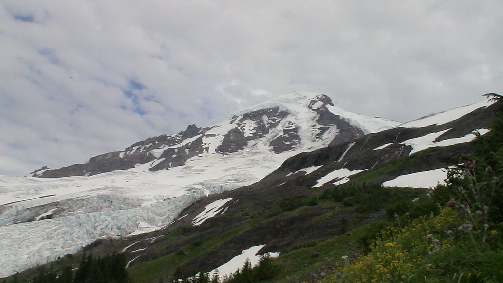
this is a view from Little Summit of Mt Constitution on Orcas Island, my home. We took this during our 'summit saturday super' where we marched up to little summit with maps, pictures, binoculars and a picnic basket. My Uncle Mark (heard in the background) was showing the rest of the family exactly where we would be hiking on Mt Baker (the mountain focused in on the distance).
Mt Baker
Excerpt form the journals of Nicole O'Neill. 
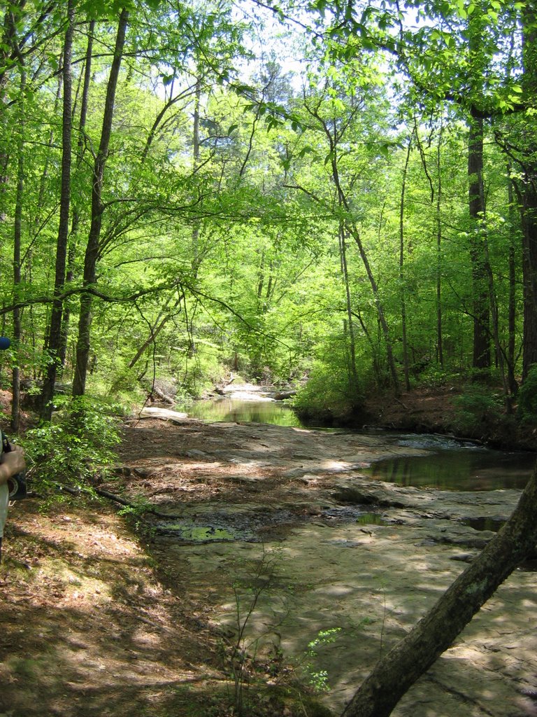
July 23rd :
First camp roughly 6 miles up into the hike. Looking up into the beautiful summit, I can hear her asking me if I am going to be ready for tomorrow and the next day. Honestly I felt I was dying at times, me going so slow, keeping the whole troope held up. At times wondering if I would be able to cut it the next day, only to be egged on by the insensate swarms of black flies or “if I reach that ridge I can finally stop singing ‘I am Henry the 8th I am’ “. By the time we hit the first alpine meadow I was singing something to the tune of 76th verse same as the first.
Although the final ridge to our first camp was hard on my mentality… I doubt it was as hard on my body as I feel I deserved it to be. It is really incredible up here, massive glacial runoff waterfalls, tumbling seracs, broken glaciers blue and dirty in their beauty. Parts of me want to climb down into the runoff next to me and feel the freezing water pour refreshingly over my sun burnt skin.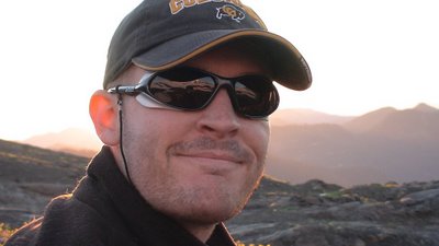
...
On a walkabout after setting up camp we headed over towards a small boulder section and found a pool of runoff that had been cutoff from the feed and had warmed significantly in the sun. What a beauty to be sitting at the foot of a glacier resting your feet in a pool the temperature of tepid bath water.
July 24th
A quick pee behind my epiphany rock and a delicious cup of camp coffee after a warm night filled with stars. Through the top of our tent you could see big dipper dumping its bucket of diamonds into the universal mix that is the Milky Way. Up here the closest light pollution is from 60 miles away, and hardly reaches the skies around the Mt Baker Wilderness. The wind is still blowing down the slope, cascading down the ridge about a thousand feet above us.
…
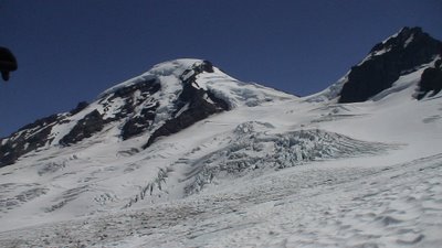
We made it to high camp!! Just below Colfax peak, 7500 feet, and the summit of Mt Baker looms outside the ‘backdoor’ of our tent. So much closer then we were down at first camp on the Hogsback.
The part I was most worried about is now over, all that lies ahead is the summit and the return all of the way back to the truck.. Now that I get a closer look I wonder if is should be worried about the summit itself and not what I just came up. The crevasse all over the mountain breathe life into the snowfields with their deep blue depths and wide chasms. Along various edges where the snow bends around the jagged rocks you can hear some ice chunks and boulders dropping. Some the size of tennis balls other the size of mini coopers.
July 25th
2 am start turned into a 3:30 am start on the summit at 7:30 left 8:30 back at high camp by 11:45. Starting out under a night sky is almost better when it comes to will power, however your first step over a crevasse as dark as the sky is enough to remind you how thankful you are that an experienced person like Mark (my uncle) is leading the group. Of course as we started up the pumice fin my legs and will power started to waiver. Then the Roman Headwall, where we were taking steps up and ice face… resorting to front pointing with our crampons up an ice runnel.
….
Our names now signed into the summit register… the crater was still smoking...
…
We tromped down to high camp, and along the way came across relatively fresh Black Bear tracks in the snowfield. It was another few hours down to our first camp on Hogsback…. then we went down that horrific rock ridge out of the glaciers and alpine meadows.
It was almost pure elation when we started crossing the various streams and waterfalls through the forest back to the truck.

July 23rd :
First camp roughly 6 miles up into the hike. Looking up into the beautiful summit, I can hear her asking me if I am going to be ready for tomorrow and the next day. Honestly I felt I was dying at times, me going so slow, keeping the whole troope held up. At times wondering if I would be able to cut it the next day, only to be egged on by the insensate swarms of black flies or “if I reach that ridge I can finally stop singing ‘I am Henry the 8th I am’ “. By the time we hit the first alpine meadow I was singing something to the tune of 76th verse same as the first.
Although the final ridge to our first camp was hard on my mentality… I doubt it was as hard on my body as I feel I deserved it to be. It is really incredible up here, massive glacial runoff waterfalls, tumbling seracs, broken glaciers blue and dirty in their beauty. Parts of me want to climb down into the runoff next to me and feel the freezing water pour refreshingly over my sun burnt skin.

...
On a walkabout after setting up camp we headed over towards a small boulder section and found a pool of runoff that had been cutoff from the feed and had warmed significantly in the sun. What a beauty to be sitting at the foot of a glacier resting your feet in a pool the temperature of tepid bath water.
July 24th
A quick pee behind my epiphany rock and a delicious cup of camp coffee after a warm night filled with stars. Through the top of our tent you could see big dipper dumping its bucket of diamonds into the universal mix that is the Milky Way. Up here the closest light pollution is from 60 miles away, and hardly reaches the skies around the Mt Baker Wilderness. The wind is still blowing down the slope, cascading down the ridge about a thousand feet above us.
…

We made it to high camp!! Just below Colfax peak, 7500 feet, and the summit of Mt Baker looms outside the ‘backdoor’ of our tent. So much closer then we were down at first camp on the Hogsback.

The part I was most worried about is now over, all that lies ahead is the summit and the return all of the way back to the truck.. Now that I get a closer look I wonder if is should be worried about the summit itself and not what I just came up. The crevasse all over the mountain breathe life into the snowfields with their deep blue depths and wide chasms. Along various edges where the snow bends around the jagged rocks you can hear some ice chunks and boulders dropping. Some the size of tennis balls other the size of mini coopers.
July 25th
2 am start turned into a 3:30 am start on the summit at 7:30 left 8:30 back at high camp by 11:45. Starting out under a night sky is almost better when it comes to will power, however your first step over a crevasse as dark as the sky is enough to remind you how thankful you are that an experienced person like Mark (my uncle) is leading the group. Of course as we started up the pumice fin my legs and will power started to waiver. Then the Roman Headwall, where we were taking steps up and ice face… resorting to front pointing with our crampons up an ice runnel.
….

Our names now signed into the summit register… the crater was still smoking...
…
We tromped down to high camp, and along the way came across relatively fresh Black Bear tracks in the snowfield. It was another few hours down to our first camp on Hogsback…. then we went down that horrific rock ridge out of the glaciers and alpine meadows.
It was almost pure elation when we started crossing the various streams and waterfalls through the forest back to the truck.
Tuesday, July 11, 2006
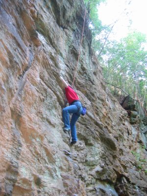
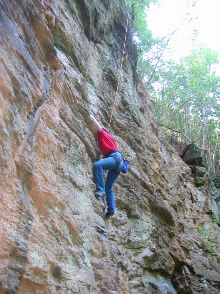
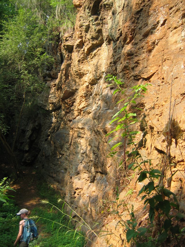
Deliverance.. CONQUERED

Last Saturday, July 8th 2006, our little ragtag group of outdoor nuts headed out to expose the deep dark secrets of the famed gorge from Deliverance. Here we were trusting our lives to Jim, our guide for the day, to 'deliver' us from the hell and torment of such locales as The Gulch, Sodomy Beach, Corkscrew, Five Falls, and Sock Em Dog. The drive that was set to take 4 1/2 hours from Augusta GA to Clayton GA through South Carolina, only took 2 1/2 hours. Despite the slow traffic detours through Anderson and Clemson. The extra time gave us a chance to go play in Helen for a bit. There is nothing like eating prime rib and fried clams while watching a one-legged man float by on a inner tube.
After setting up camp at Tallulah River Campground at a beautiful bend in the river, we sat down to the damp wood crackling under a newly lit fire. Around our campsite danced the lights of fireflies and the playful echos of children.
The trip itself was incredible, we passed by countless quality photo shots. The morning light barely filtering into the gorge, it's softness playing off of the rock faces and fast moving water. Along the way our guide, Jim, made sure to point out all of the major scenic points, 'sodomy beach' 'deliverance rock' 'rabun clifs' etc.. etc.. that were scattered here and there between the major rapids that had been run enough times by others to garner their own names, and their own places in the history books.
I am not sure what to say about the whole experience, I can't think of good collection of adjectives and nouns that could aptly describe the fun that we had in such a short time. However, to those of the Chattooga river crew... you know exactly how it was... and how much fun we had!! Here is a toast to you, I hope that all your rapids are big, your company great, and your trips memorable!!
Monday, June 26, 2006
UPDATE
Just a few updates for those watching the site.
The pictures from the quarry climb are now finally posted on to the south east climbers website. Feel free to check those out and see some of the picutres that for one reason or another wouldnt load on to the homepage.
Also we will be putting the July Calendar out sometime this week, so keep your eyes and ears open for that to be posted on the website and to be coming to some of you via 'high email'. As always we are always looking for input or suggestions, feel free to contact us at outdoor.adventures@backpacker.com
On a side note, I will be leaving to go climb Mt Baker on July 15th, and will be gone for 2 1/2 weeks, following that I will be going on a short (4-6 month) deployment at which time Merryl will be taking over all of the fun stuff. If you have any questions or what have you, you can still contact her/us at the above listed address.
I was just recently asked to write an article and provide some pictures for the NIOC G's quarterly magazine the 'Navigator'. Hopefully the editor will approve the article and the photos, and you should be seeing it in the upcoming edition.
As always, if you have any photos that you took on a trip, we would love to have some copies. Preferably digital, and we would LOVE to put them on the website if you could send them via email. Please include the name of the subject, the location, and the date if possible.
As always, have a great day and I hope that even though the weather hasn't been the most conducive to being outdoors, that you are like me... drooling over topos and planning the next trip before the first one has ended!!
Be Green, Stay Happy
Nic, Lead Guide Outdoor Adventures.
Tuesday, June 20, 2006
SC Quarry Climb
We had a great time climbing the new lines at the abandoned South Carolina Quarry. With Merryl, Amber, Tom and myself we succesfully topped out on the two main lines that we could find decent anchor points to. Hopefully the photos work out off of this page, but if you would like copies, or are interested in seeing all 93 of the photos we took that day, then just contact us at outdoor.adventures@backpacker.com
The wall does extend about 150 feet with a maximum height of 50. (ave 35ft) there are at least 3 really good bouldering sections, with one caved out area that almost requires anchoring in due to the incredibly poor landing zone, and lack of ample area for a crash pad or a catcher. (pictured to the right is the side of the caved out bouldering section)
Due to lack of a decent area to belay and good anchorage, we were restriced to the northern section of the quarry, which we named dynamite wall.
((ratings are approximate, and on the yosemite scale))
'Wasp' starts out on the main 'dynamite wall' as an easy 5.8 then at the top, after the 1st small ledge, becomes a 5.10 with the majority of the holds consiting of finger pinches and slopers. There is one decent pocket hold at the top if you shove your left hand in, however after that it's finding the right finger jams that become a problem. Oh and staying away from the wasps nest!! :)
'Lichens Journey' is a much easier 5.8 with a decent set of holds the whole way up. This route is set off of the main dynamite wall closer to the bouldering cave with great ledges.
Due to a complication, more photos will be posted shortly, I apologize for the delay. Until I am able to fix the problem here on blogger, please feel free to check out the photos at the southeast climbers coalition site...
www.seclimbers.org. Check under South Carolina, and other areas to view photos. The photos might not be available on this site till at the soonest June 21st..
also check on www.rockclimbing.com under routes, usa, south carolina, north augusta, quarry. and that's us!! of course this isn't all of the pics, but it can start giving you an idea!
The wall does extend about 150 feet with a maximum height of 50. (ave 35ft) there are at least 3 really good bouldering sections, with one caved
 out area that almost requires anchoring in due to the incredibly poor landing zone, and lack of ample area for a crash pad or a catcher. (pictured to the right is the side of the caved out bouldering section)
Due to lack of a decent area to belay and good anchorage, we were restriced to the northern section of the quarry, which we named dynamite wall.
((ratings are approximate, and on the yosemite scale))
'Wasp' starts out on the main 'dynamite wall' as an easy 5.8 then at the top, after the 1st small ledge, becomes a 5.10 with the majority of the holds consiting of finger pinches and slopers. There is one decent pocket hold at the top if you shove your left hand in, however after that it's finding the right finger jams that become a problem. Oh and staying away from the wasps nest!! :)
'Lichens Journey' is a much easier 5.8 with a decent set of holds the whole way up. This route is set off of the main dynamite wall closer to the bouldering cave with great ledges.
Due to a complication, more photos will be posted shortly, I apologize for the delay. Until I am able to fix the problem here on blogger, please feel free to check out the photos at the southeast climbers coalition site...
www.seclimbers.org. Check under South Carolina, and other areas to view photos. The photos might not be available on this site till at the soonest June 21st..
also check on www.rockclimbing.com under routes, usa, south carolina, north augusta, quarry. and that's us!! of course this isn't all of the pics, but it can start giving you an idea!
Saturday, June 17, 2006
NEW CLIMB!! FIRST ASCENTS!!


If anyone is interested, this is a very rare chance to redpoint/first ascent a new wall that until now is not known to have ever been climbed. Please contact me asap or show up at the North Augusta Boat Ramp Parking Lot, above the water plant on Monday at 8am.
if interested feel free to call at 267-8808 or contact us at outdoor.adventures@backpacker.com
I apologize for the odd stitching of the photos, hopefully they are seamless enough that you can get a rough idea of what the wall will look like.
Friday, June 09, 2006
Parkour
We have been looking to add Parkour in to our scheduling, and I have been getting alot of questions asking me about the basics and what have you.
Parkour responds to a deep-seated need of humans: to move. It's an art that demands the true spirit of a warrior, and offers pure action to its practitioners.Basically, Parkour is a natural method to train the human body to be able to move forward quickly making use of the environment that's around us at any given time. This 'art of displacement' require neither specific structure nor accessory for its practice. The body is the only tool. It's an athleti discipline accessible to all, because it combines all the natural skills of the human body: running jumping, climbing... It's a sport that permits exploration of the potential offered by your body.It's about being able to face the obstacles with which you are presented, whether they be in the natural environment or in the urban environment, in a search for movement that combines effectiveness and control
several sites with vids...
www.parkour.com
my favorite one - Mr. Jumperson The actors features have been doing parkour almost since it's inception in France. This is actual a commercial, see if you can spot for what.
and also http://broadbandsports.com/node/207
type in any search engine the following tags to find more information or movies
freerunning, parkour, urban running,
Tuesday, June 06, 2006
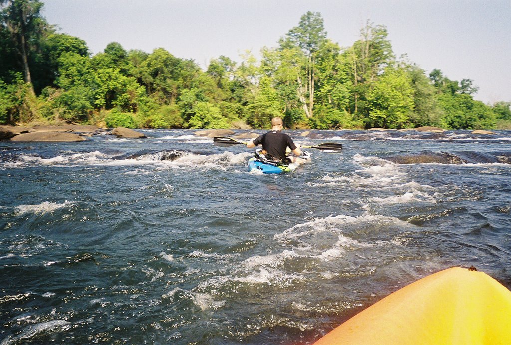
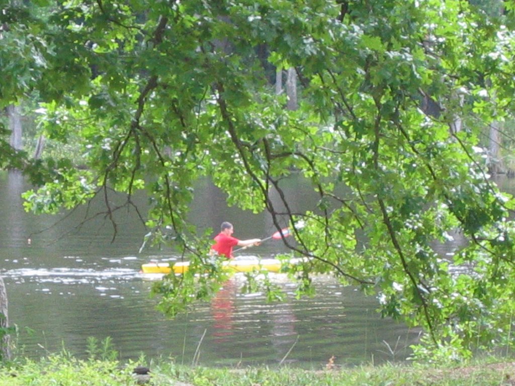
May 28th Kayaking Trip

Curtis floating in a bed of rare Shoal Lilies
Curtis, Laura and Chuck went down on this gorgeous kayaking trip on May 28th 2006. Curtis sent these pictures in to share with all of you and hopefully they inspire you to come out and join us.

whats wrong with this picture?
A little bit of whitewater in the Shoals
As always, if you are interested in joining us on one of our trips feel free to contact us at outdoor.adventures@backpacker.com
Monday, May 29, 2006
JUNE CALENDAR
Please email outdoor.adventures@backpacker.com for further details.
June 1st & 10th- Kayak the Savannah from Savannah Rapids Pavilion to Downtown Augusta. free, please RSVP
June 2nd, 9th, 16th, 23rd, 30th - Aiken climbing wall 5:30pm cost $5 for drop in
June 3rd National Trails Day Hike and Map Peekaboo trail 6pm
June 4th&21st Hike and Geocache Bartram Trail
June 5th GUIDE MEETING 5PM CYPRUS LODGE BASE MWR
June 7th, 22nd & 26th Hike Mistletoe Cliat Creek
June 8th Kayak Rolling Class 7 pm
June 9th Bouldering Savannah Rapids Pavilion 7 am
June 11th Nature Walk, site TBD
June 11th&24th Kayak the Canal from Savannah Rapids Pavillion down to the Enterprise Mill
June 17th Hike the Peekaboo trail 8 am
June 18th Kayak/camp overnight trip - if interested please RSVP ASAP, exact campsites on the Strom Thurmond Lake will be determind by the members attending. All gear is provided free of charge.
June 19th Kayak Rolling Class 5 pm
June 25th Hike Stevens/Turkey Creek
June 27th-29th Big Trip possible Kayak the Broad River. Anyone available for these dates that is interested in an overnight camping/kayaking/bouldering/hiking or what have you trip. Please contact us ASAP.
Wednesday, May 24, 2006
ATTENTION CORE GUIDES
ATTENTION TO THE CORE GUIDES
We have the possibility of something really big in the near future and I need everyone to get back to me on whether or not they are available on June 5th at 5pm. Thanks
either call, or use high or low email.. OUTDOOR ADVENTURES
We have the possibility of something really big in the near future and I need everyone to get back to me on whether or not they are available on June 5th at 5pm. Thanks
either call, or use high or low email.. OUTDOOR ADVENTURES
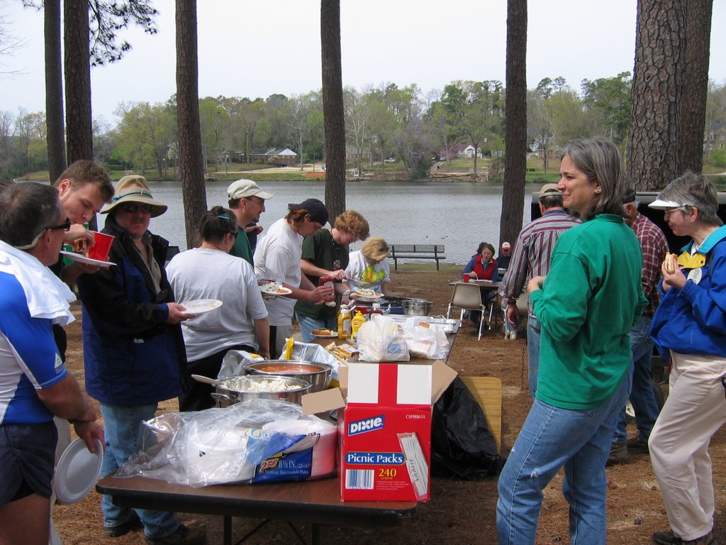
Command Picnic

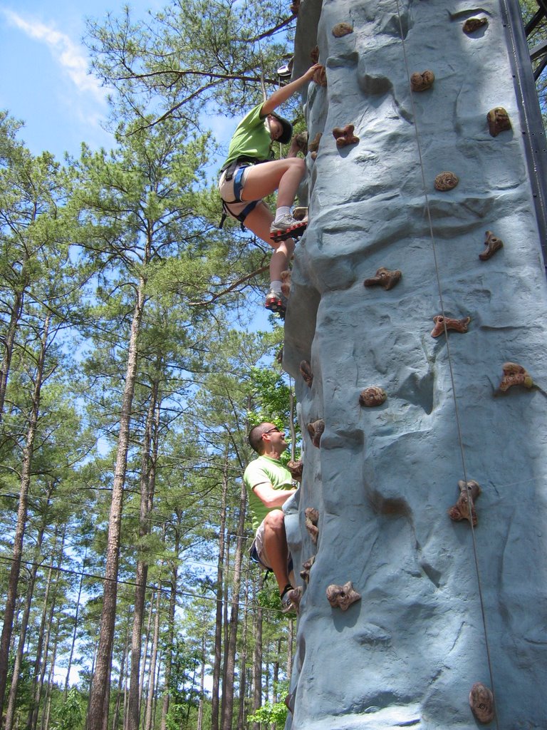 Our Command Picnic was a blast. Thanks to everyone that helped out. Chuck, Merryl, Allison, Curtis and all of our other helpers.
Here of course are some photos and a quick video clip from the command picnic. Enjoy!!!
Click on the photos to see an enlarged version of them.

 The climber in the pink shirt is Dakota, and later on (not shown in video clip) she showed up some of the men on the ground by not being afraid to top out and rappell back down, way to go fearless little girl!! One after my own heart.
Friday, May 05, 2006
Command Picnic
May 19th 11am-2pm
Come out and show your support for the Navy and for Outdoor Adventures at the annual spring command picnic. This year it will be held at Leitner Lake, on the back acres of the fort. We will be hosting a booth with a full set up campsite, first aid booth, kayaks, Leave No Trace, the latest beta for the area, and various other outdoor activities. Stop by and show your support!!! You can easily spot one of the crew this year, all the guides in attendance will be wearing personalized 'kermit the frog' green t-shirts with the word GUIDE on the back. Ask any of us any outdoor questions that you might have, we are more then glad to help.
Driving Directions from base: Take 15th to N. Range Road, hang a right and continue past the abandoned ID and Vehicle Checkpoint (gate 7).
Pass the signs and turnoff for the Controlled Lakes. When you come to a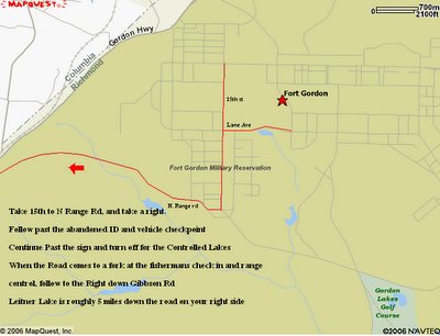 fork in the road at the Range control and Fishermen checkin, go to the right down Gibbson Road. Leitner Lake is about 5 miles down the road on your right.
Click on the Image to the right to see driving instructions
Come out and show your support for the Navy and for Outdoor Adventures at the annual spring command picnic. This year it will be held at Leitner Lake, on the back acres of the fort. We will be hosting a booth with a full set up campsite, first aid booth, kayaks, Leave No Trace, the latest beta for the area, and various other outdoor activities. Stop by and show your support!!! You can easily spot one of the crew this year, all the guides in attendance will be wearing personalized 'kermit the frog' green t-shirts with the word GUIDE on the back. Ask any of us any outdoor questions that you might have, we are more then glad to help.
Driving Directions from base: Take 15th to N. Range Road, hang a right and continue past the abandoned ID and Vehicle Checkpoint (gate 7).
Pass the signs and turnoff for the Controlled Lakes. When you come to a
 fork in the road at the Range control and Fishermen checkin, go to the right down Gibbson Road. Leitner Lake is about 5 miles down the road on your right.
Click on the Image to the right to see driving instructions
Thursday, May 04, 2006
May Calendar
May 4th & 22nd Kayak the Savannah Near Augusta - depending on conditions we will launch at the Savannah Rapids Pavillion, or into the canal and portage over at Riverside Park. Then we will kayak the flat water of the Savannah River to downtown Augusta. We will pull out at the ampitheatre next to Boll Weevils. Conditions prevailing, expect the trip to last about 2-3 hours.
May 6th Pops Concert - Although this is not a 'sport event' this is a free oncert put on by the Augusta Symphony. Starts at 7pm at the Universtiy Healty center on Belair rd near Washington.
May 7th Augusta Canal Cruise and Cookout- see www.augustacanal.com
May 10th Bouldering on Local rock - we will be going to some local outdoor features. Problems will be more horizontal then vertical. This is a great oppurtunity to get back onto the rock or train for harder climbing.
May 11th Mountain Biking at Lick Fork Lake - located in South Carolina about a 45 min drive from where the I-20 crosses the Savannah River. This approx 6 mile course is maintained by SORBA and is pristine. It offers a somewhat challenging singletrack loop up and down hill..
May 13th Kayak the Toccoa and Overnight Camping at Deephole - Deephole campground is located about 45 minutes north of Dahlonega in northern Gerogia and is situated in a bend on the Toccoa River. On average the toccoa is rated a class I-II with 1 class III rapid in the middle. The river meanders through pristine national forest and then past rolling farmlands until the take out, about 12 miles downstream. Please RSVP
May 15th Augusta Canal Night Cruise - see www.augustacanal.com
May 18th Hike and Map of Peekaboo Trail on Reed Creek - a short hike where the trail is still in the process of being established. We need help clearing the trail and mapping it's route.
May 8th, 19th, 30th Hike the Bartram Trail - call for times
May 12th, 17th, 28th Hike the Mistletoe Cliat Creek and Rock Dam trail - call for times
May 21st Inagural Locks Cruise - contact www.augustacanal.com
May 23rd Overnight Camping at Mistletoe State Park - we will hike in to the backcountry site, roughly 4 1/2 miles, Please RSVP
May 26th Mountain Biking near the Canal - recently an Eagle Scout completed his project of establishing a set of mt biking trails off the Augusta Canal Tow path near where the Riverwatch Parkway crosses over the Canal.
Tuesday, April 25, 2006
Rain in Augusta
For those of you back home you wanted to see what it was like when it rains here in Augusta. This is a good example of a 'sprinkling' and some of what Georgia has to offer. This however is not a full on rainstorm, because there is not a foot of standing water on the high ground. and yes, I do know my eyes look a little creepy in this video clip.
Reed Creek
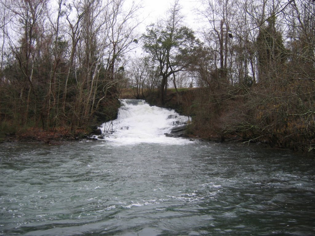
Reed creek actually passes by my house up near the Lakeside Panthers High school, and the trail that modestly follows it near out house is one of the dogs favorite tromping grounds. We have been trying to figure out a way around the various obstacles, so that maybe we could run the creek at high water (regular level is bottom scraping) from our house down to the Augusta Canal where the creek dumps out at this set of low waterfalls : 
The first waterfall is the biggest at roughly an 8 foot tiered drop with the line flowing down river right. This isn't even worth attempting at low water due to the launch and scraping at the top. A quick seal launch can be done from river left above the downed tree. The regular flow pulls hard to the right but there can be enough of a tug to pull you down on top of the tree.
 The next rapid is a lot smaller and the best line also follows the v in the rock on river right. At high water the force of the rapid can easily push a kayaker into the soft sand wall on river right. Due to the structure of the wall it has been eroded in several sections creating small caverns that could easily trap a boat. A few good strokes should put you
  well and clear of this.
This third photo is looking from the top of the last rapid.
Access to this little park and play is very easy.
Directions : Take Evans to Lock Rd. East till it dead ends at the Savannah Rapids Pavillion. After the stop sign take a right into the gravel parking lot and go to the very end. There is the head of a short trail at the edge of the parking lot. Sadly, it is currently marked with a busted up microwave.

You can either follow the short trail to the right and put in off of the 'erosion bank' or you can follow the trail to the left and get on top of the small waterfalls for a look at them yourself.
The first waterfall is the biggest at roughly an 8 foot tiered drop with the line flowing down river right. This isn't even worth attempting at low water due to the launch and scraping at the top. A quick seal launch can be done from river left above the downed tree. The regular flow pulls hard to the right but there can be enough of a tug to pull you down on top of the tree.
 The next rapid is a lot smaller and the best line also follows the v in the rock on river right. At high water the force of the rapid can easily push a kayaker into the soft sand wall on river right. Due to the structure of the wall it has been eroded in several sections creating small caverns that could easily trap a boat. A few good strokes should put you
  well and clear of this.
This third photo is looking from the top of the last rapid.
Access to this little park and play is very easy.
Directions : Take Evans to Lock Rd. East till it dead ends at the Savannah Rapids Pavillion. After the stop sign take a right into the gravel parking lot and go to the very
 end. There is the head of a short trail at the edge of the parking lot. Sadly, it is currently marked with a busted up microwave.
You can either follow the short trail to the right and put in off of the 'erosion bank' or you can follow the trail to the left and get on top of the small waterfalls for a look at them yourself.
Dusk in the hidden garden

There is a secret garden along the banks of the Savannah, and it is truely right  underneath everyones noses and they dont realize it. We descended the hidden stairwell on a beautiful day following several
 underneath everyones noses and they dont realize it. We descended the hidden stairwell on a beautiful day following several
 days worth of rain. Although we were surrounded by trees, the light mist from the spillway saturated our clothing before we reached the river. 

What better way to spend a sunset then with friends dangling their feet in the water and perfect weather.
Bartram Trail
The Bartram Trail extends from Louisiana to North Carolina, and passes through Georgia. Augusta sits smack dab in the middle of a portion of the trail, and thankfully they have restored some of it near the Augusta Canal, and also near the Strom Thurmond Dam.
The hike along the S. Thurmond lake is absolutely beautiful and often times on the weekends I have seen trail joggers/runners and a few mt bikers out there. The trail meanders through the Georgia side of the Dam, on the southern edge of the lake. In several locations you can easily walk down to the lake for a refreshing and secluded dip in the perfect water.

A word of caution, this is also prime hunting grounds for wild turkey and deer, during the hunting season it is imparative that you and your dogs where orange or yellow reflective vests, unless you want a personel Cheney accident to talk about.
Directions :
Take Fury's Ferry (Hwy 28) Into South Carolina. take a left onto Jake Pollard Highway (HWY 221/HWY 150), you will pass over the Dam. About a mile after crossing the Dam look on the right for small parks. Several of these day use parks have access to the Bartram Trail.
Or take Washington Rd ( HWY 47 ) west till you come to Jake Pollard Highway (HWY150) take a left and go roughly 5 miles and look on the left for the same parks.
Tuesday, April 18, 2006
how many do you burn?
Ok, I admit it.. I am not in the best shape of my life, but who is in this day in age in the great society we live in. So, to determine generally how many calories I spend in a day, I fiddled around on a few sites to find out on average how many calories I would burn doing some of my favorite activities.
Here comes the shocker, I am going to say my weight and my estimated BMI/BF!! On average I am about 165, according to the Navy standards I am 31%, although by other calculations I am roughly 26. My BMI is roughly 25, so that means for 60 minutes of mt biking 857, fencing 605, frisbee, general 302, ultimate frisbee 806, kayaking on flat water 504, rock climbing 1109, sky diving 353, Backpacking with a 35-45lb pack 445.5, whitewater rafting 956.
I would say that would give you a fairly decent look into how each event stacks up and also what sort of preperation certain sports take.
If you are interested in finding out what a generalized calculation for your own standards, type in "activity calorie calculator" into your preferred search engine. my searches took at least 3 pages
Monday, April 17, 2006
A Walk in the Woods
 April 16th myself, Tom and the dogs went for a short hike along the trails at Mistletoe State Park. Everytime I go on a hike through these woods it's a completely new expierence, especially now that spring has come and everything is in bloom. We entered a magical world of filtered sunlight and honeysuckle the farther we crept along. The dogs on the other hand, found even more frogs and other creepy crawlies out in the swamps and creeks.
If you look back several posts, you can tell the difference between only a few months.
This was just funny and I thought I should share it.
some of the upcoming events at Mistletoe:
Brain Tanning WorkshopSaturday, Apr 29, 2006 8 AM - 3 PM
Learn firsthand how early Native Americans tanned deer hides to make soft, pliable leather. Bring a lunch and wear old clothing. Call to confirm date. $3 parking. 706-541-0321.
Introduction to Fly FishingSaturday, May 6, 2006 10 AM - 12 PM
Anybody can drop a worm from a pole, but there's a real art to fly fishing! You will learn what you need to get started fly fishing: type of equipment, basic flies and casting techniques. Bring a chair and a fly rod (if you have one.) Register by April 30. $3 parking. 706-541-0321.
Talking TurkeySaturday, May 13, 2006 10 AM - 12 PM
Calling all gobblers who can yelp, purr or cackle! Children and adults will learn to make turkey calls from everyday items. $1 plus $3 parking. 706-541-0321.
Campfire ProgramSaturday, May 13, 2006 7:30 PM - 8:30 PM
Bring your chair and gather around the campfire for an old-fashioned camp program of songs, skits and stories. $3 parking. 706-541-0321.
RaptorsSaturday, May 20, 2006 7 PM - 8 PM
The Science Center at the University of South Carolina-Aiken will bring a Red-Tailed Hawk and Barred Owl for this fascinating program on raptors. $3 parking. 706-541-0321.
Wilderness Survival TrainingSaturday, May 27, 2006
Session one 11 a.m. - Noon; Session two 7:30 -8:30 p.m. Learn basic first aid, including how to deal with ticks and how to avoid hypothermia. Learn about plants and how to use them, and also learn to make a fire without a match. $3 parking. 706-541-0321.
Friday, April 14, 2006
for the kayakers
How to roll :
Roll index
To Give you a bit of inspiration : Kelsy on the Garburator in British Columbia
Roll index
To Give you a bit of inspiration : Kelsy on the Garburator in British Columbia
Wednesday, April 12, 2006
Interesting Article : The Sexes vs. Altitude
This is taken from www.bodyresults.com :
Women's Fuel Usage At Altitude Vs. Men
Braum, B., Butterfield, G. E., Mawson, J. T., Muza, S., Dominick, B. S., Rock, P. B., & Moore, L. G. (1997). “Women at altitude: Substrate oxidation during steady-state exercise at sea level and after acclimatization to 4300 meters elevation.” Medicine and Science in Sports and Exercise, 29(5), Supplement abstract 784.
This study looked at sixteen women over a period of 12 days who were in either the follicular (pre-ovulation) or luteal (pre-menstrual) phases of their menstrual cycles at sea level and again at Pike’s Peak (14,109’). The ovarian hormones progesterone and estrogen may cause women to acclimatize to high altitude differently than men, and variations in both hormones in the follicular and luteal phases of the cycle may alter the responses. After acclimatization to high altitude, weight-stable men tend to use more carbohydrate as an exercise fuel compared with at sea level. Women, on the other hand, oxidize less carbohydrate and more fat at 14,109’ compared to utilization at sea level. This is one more study that shows consideration of the peculiar female response to exercise and altitude is warranted. Treating women with the identical training and adaptation principles as men is an erroneous coaching strategy.
Take-home message:
Along with the research discussed and summarized in our high-altitude nutrition article at www.bodyresults.com/E2HighAltitudeNutrition.asp, this research seems to point to another reason why women, who naturally have more bodyfat to begin with, may do better at altitude than men. When fueling your own alpine excursions, carefully note what works best for you in terms of macronutrient ratios (carbohydrates-protein-fat) and compare that with the ratios you prefer (for maximal energy) at sea level. If you tend to have trouble at altitude, simply changing your nutrition strategy can provide relief. While a registered dietitian, nutritionist, or male friend might be able to suggest foods that should be good fuel sources, only you will know what works best for you during particular phases of your cycle.
Various interesting movies and sites
This is another really good site for whitewater. The pictures are incredible and they have some great videos on there. Most of the pictures are done by Samantha B. Swing by and check them out!
Add on to that, just for your humour, this may be the new olympic SPORT !!
Add on to that, just for your humour, this may be the new olympic SPORT !!
Sunday, April 09, 2006
Savannah River trip April 9th 2006
 We took off today, April 9th, FINALLY! We were supposed to go yesterday but unfortunatley we had a minor glitch when a Georgia style monsoon came in. HA weathermen... said it was only a 20% chance of rain.
 We put in just below Strom Thurmond Dam on the South Carolina side. (next to the powerplant) Thankfully this time the weatherman said 20% chance of rain... it was clear and beautiful.
 A few times we stopped and played musical boats, by the way good job Erns in my little Dagger. After we were about 1/3 of the way into the trip we took a slight detour and headed off down one of the side canals that passes through the golf course near Windmill plantation and pops out just above Fury's Ferry Road. Of course, we sent Chuck with his bowie knife ahead of us to look for alligator tracks :) lol.
 We couldn't have asked for better weather or better company. Surrounded by baby turtles
 (Laura's favorite), yellow bellied slider turtles, snaper turtles, alligator gars, (spelling) great blue herons, white egrets, cormorants, and many many other various birds and fish. We were even graced at the very beginning of the trip with a Bald Eagle sighting near the Strom Thurmond Dam.
 Thanks to Chuck Elliot for the kayaks and gear and thanks to everyone that came out, Pam, Brandi, Laura and Curtis. Hopefully you guys had a wonderful time!! **wink wink nudge nudge.
We took out at the Savannah Rapids Pavillion, but if you were to continue on you would either have to portage around this spillway,
or go for it!! ala Jason Benton . The chute that he goes over is located on the South Carolina side on the very far right of this picture. It is marked 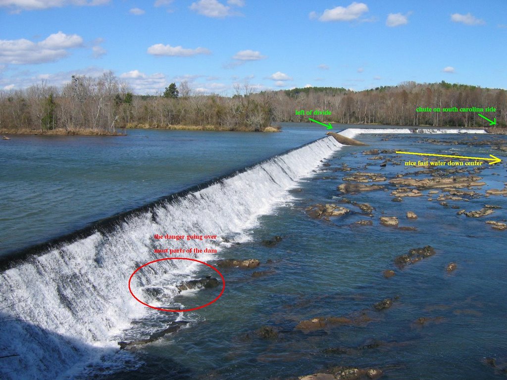 with a green arrow. As you can see in the movie clip, it's not a bad little chute, but it can be unnerving for someone who hasn't paddled alot to try and go under the log and down the 10ft face. However, it can be worth it on a low-med water day. :)
Saturday, April 08, 2006
Mistletoe Rock Dam

The Mistletoe Rock Dam trail is a perfect retreat from the trappings of the 'city'. It is roughly 4 miles from the head of the trail out to the primative campsite at Rock Dam Creek.
 Thankfully this trail and the few primative campsites are on the opposite end of the park as the rest of the campsites, so you will not encounter any rv's, plumbing, or noisy neighbors. The site at Rock Dam is rated to take up to 30 tents, (very easily can) and has 3 rock firepits and one picnic bench.
  The trail out there meanders through the forest, following 2
  streams and crosses over several old fire roads. During the spring and summer months you can find small swamps and drainage ponds teeming with life within several feet of
 the trail.
 This time of year is especially beautiful with the various wildflowers in bloom, dogwood trees, wisteria, honeysuckle, wild iris, trumpet flower, and many many more. So, if you are prone to allergies, best bring the claritin, cause pollen from the pines and the various flowers coats EVERYTHING.
 Lake Olmstead Clean up
As a part of the 'rivers alive' event, we helped clean up Lake Olmstead and the downtown portion of the Augusta Canal. Thanks to everyone that came out and helped, we pulled over 100 full size garbage bags and misc. other items. Now the kids of the area have a safe clean waterway to go and admire and play 'with'. (sorry no swimming).
 That's Chuck on the far left with his back to the camera and on the far right is Rebecca and Margret from the Augusta Canal Interpretive Center. The backdrop is the freshly cleaned banks of Lake Olmstead.
 That's Chuck on the far left with his back to the camera and on the far right is Rebecca and Margret from the Augusta Canal Interpretive Center. The backdrop is the freshly cleaned banks of Lake Olmstead.
Monday, March 27, 2006

Sometimes you have to look in the oddest places for some climable walls in the Southeast. In fact this is one of the old walls the is a part of the locks at the top of the Augusta Canal. It is only 8ft high but it's about 200 feet long and was built with large rocks in the face. eh eh eh!! decent handholds and footholds for people to get to know how their body works when hanging on to the rock. This is usually where I take people that have never had some face time.
Murder Creek Beta


Headed out toward Macon and found these neat little boulders to get the newbies started on. About a month later came back with some friends and crammed and jammed. Also took a little run down Murder Creek itself off the final ledge. Water was a little to low for a decent
 run however. I think we scared the locals more than anything. Talk about a sceen from 'Deliverance', with the fresh 'swaztikaz' (their spelling) and the single tooth teenager drinking beer... I dont know who looked funnier, us with rock shoes and chalk climbing boulders and sliding down the creek or them?
Rae's Creek Overflow

These are from the Rae's Creek overflow at the Augusta Canal on a heavy flow day. Eventually I plan to seal launch at the top just below the road (about 10 feet from the lip of the first drop) and then this rapid. This is an easy park and play, with a decent pull out for rescue.
Here is a quick movie of Jason Benton running the Overflow
across from this waterfall. You can see the fall in the distance at the end of the shot somewhat hidden by trees.
Subscribe to:
Posts (Atom)